Eastern Highlands
Driving in the Eastern Highlands of Mpumalanga Panorama Route has always been a feeling in ‘wonderland’. I drove through the mountain range ascending towards Nelspruit City, the capital of the Mpumalanga province. The town lies in the eastern half of South Africa as you almost head towards Swaziland and Mozambique.
It’s not the highest of the range of mountains I drive in my daily work, but unique to the terrain is the evergreen vegetation in this tropical rain region of South Africa. There is a steep ascend as you leave Nespruit to White River Town with sharp curves, thank goodness the road is wide and well maintained.
The small town of White River is so smart, busy with farming communities that bring there produce and of course get there upkeep necessities. I and other Tourists I meet here are happy to get the services like gas stations, banks and shops.
Graskop
Heading north from White River i drove up to Graskop Town past the Sabie river. The Sabie river is one other big river that flows Kruger national park supplying the all important water for wildlife. Graskop is quite a small town. A few shops here are mainly coffee shops and quite a number of lodges. That says a lot about Tourism in the city. Once I had stayed at Pilgrims.
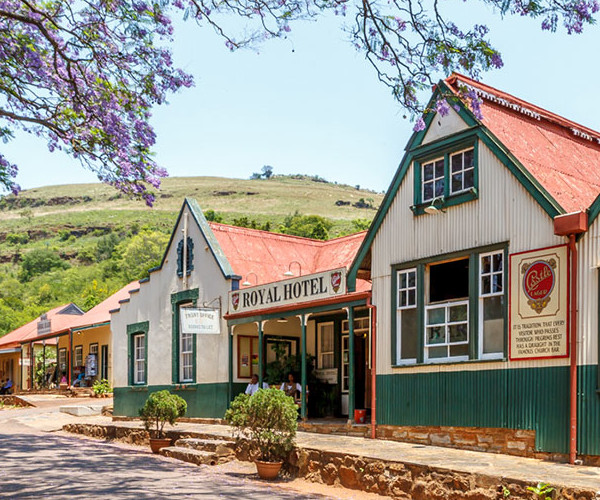
Pilgrims Rest
The whole town of Pilgrims Rest has been declared a national monument. Back in 1873, Alex Patterson was one of the many gold miners who had travelled from as far as Kimberly and Cape in search of gold. Known as the ‘wheelbarrow Alex’, a loner who needed no company, had discovered alluvial of gold when he left the Macmac diggings. Pushing his wheelbarrow up the hills following a game trail he came to Peach Tree Creek where he discovered real gold.
Only after registering his claim, the whistle blew and Pilgrims Creek became the World attraction for real gold in Southern Africa. Officially Pilgrims rest was proclaimed a gold field and the scatter of tents , shacks soon grew into a flourishing little village complete with sturdy brick houses, shops, canteens etc. The Royal Hotel built then and the church built then are still a center of attraction in Pilgrims Rest. It’s a beautiful village
The scenic roads winds up and down on sharp curves and blind corners on a narrow roads. The canopy of big trees hangs on top and their shadows cool the road. Graskop is bear. No trees no boulders just short grass on typically sandy hills.
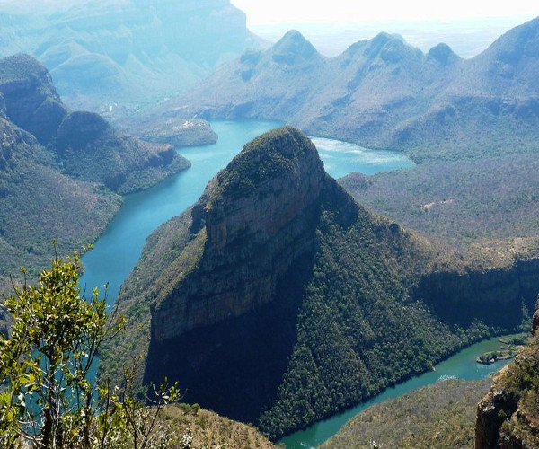
Three Rondavels
A few kilometres from Graskop I came to the Drakensberg escarpment. The driving is all that gets me so excited and one has to concentrate much. I took a break on the 3 Rondavels.
African huts are round and thatched. Traditionally the rondavels ‘ round huts’, are significant in most ways than just providing shelter. These where kitchens, dining rooms, sitting rooms, clinics, old peoples homes, counselling and cultural class-rooms, and everything that’s African. Marriages and ‘lobola’ negotiations were carried out in the Rondavels.
So the natural resemblance of the Rondavels on a Hill-top on these mountains brings a sense of the old-times at the same time appreciating the natural process of volcanic and weathering that has shaped these huts-like structures. And most surprising its not one but three.
The Rondavels looks down on The Blyde River Canyon. The third biggest canyon in the world and the big ‘green canyon’. Spectacular blue water is the feature of the canyon on a sunny clear day. Contrary to the Graskop mountain , here it’s quite rocky with subtropical vegetation covering the canyon.
The Blyde River Canyon
This is truly South Africa’s beautiful natural sites. The view is mind blowing and cool breeze from the canyon on a hot day is just what you need. Its well conserved with thick vegetation and wildlife.
I drove 10 km from the view of the 3 Rondavels and the canyon to the Bourke’s Luck Potholes on the Blyde River. At the confluence of the Blyde River and Treur River a unique geographical feature has been created. The sandstone bedrock has formed huge cylindrical potholes due to the swirling eddies of water when the two rivers meet. Over thousand years of spectacular erosion today the colourful natural feature has bridges and walk ways for visitors to view.
The name came from John Bourke, one of the first to have proclaimed that the area had gold and had his claim nearby . Unfortunately he did not get any ounce of gold and walked away but years later other prospectus found huge amounts of gold in the area.
God's Window
Perhaps the most striking of all is God’s Window. The beautiful sight of the valley below viewed from the top of the mountain is way out of this world. This is the highlight of the panoramic view. The view of the lowveld 900 metres down of a lush indigenous forest. The cliffs, the forest and the hills can be observed as far as you eye can take in. The mountain that has the God’s Window is the vintage point as well as a rain forest that is mostly misty and foggy and has exotic plants. I enjoyed the hike up, observing different creatures, insects and parasite plants on a very long trees.
God’s Window is indeed as the name implies. Once here you would wonder no more what inspired the name. A little less than 10 km from here there is the Lisbon Falls.